南湖新闻网讯(通讯员 孙瑞 黄泽华)近日, 我校资源与环境学院孟冉老师团队与美国马里兰大学、美国南方卫理公会大学、蚂蚁集团、香港大学、新加坡大学、中山大学、华中师范大学等单位合作,在生态环境遥感智能监测方面连续取得重要进展。
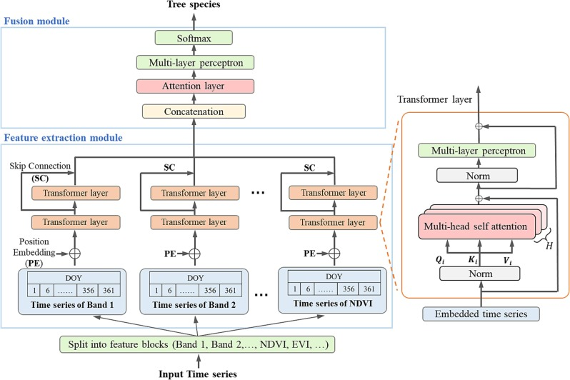
图1. Transformer4SITS网络结构图
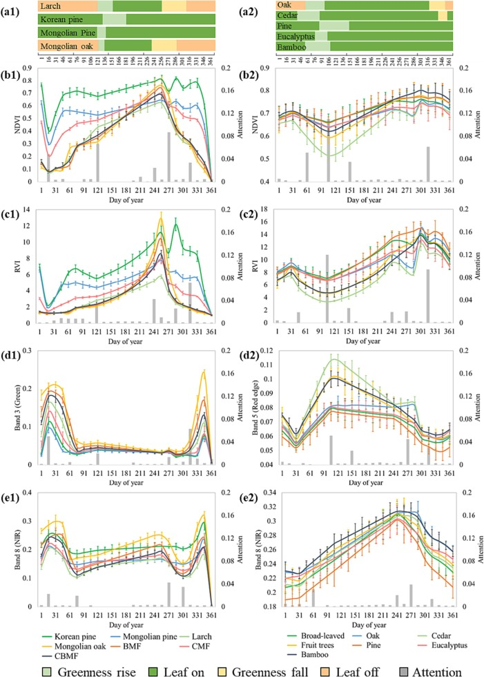
图2.树种遥感时序特征和注意力分布信息,误差条表示统计中的标准差
人工林在过去几十年内快速扩张,逐渐成为全球生态系统的重要组成部分,发挥着巨大的生态效益。基于遥感数据监测人工林的树种分布对人工林的管理与保护具有重要意义。然而,遥感影像时间序列中大量的输入特征、复杂的时序和结构信息极大的增加了时间-光谱特征的维数和特征提取难度,对多数缺乏时序特征学习能力的通用分类器提出了挑战。针对这一问题,孟冉团队基于深度学习Transformer网络开发了一种面向遥感影像时间序列的自适应关键光谱时间特征提取方法(Transformer4SITS,图1),可有效自适应提取树种高可分性时间-光谱特征,有效提高大范围区域内的树种分类精度(图2)。研究成果以“A spectral-temporal constrained deep learning method for tree species mapping of plantation forests using time series Sentinel-2 imagery”在ISPRS Journal of Photogrammetry and Remote Sensing发表。
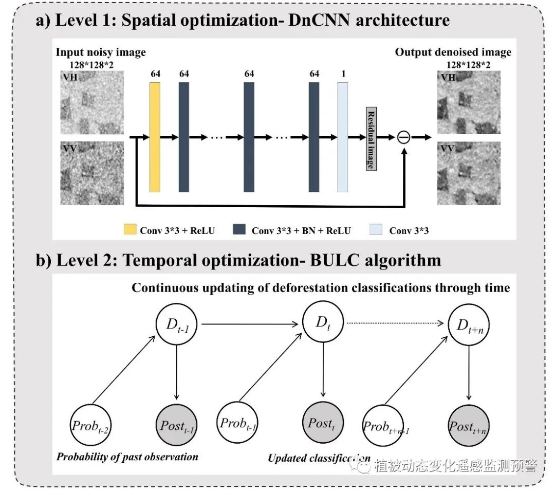
图3. 基于S1卫星数据的多级时空优化方法示意图
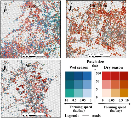
图4. 毁林斑块的季节性、大小和形成速度,以5平方公里的六边形网格内的平均值表示。
准确地毁林(如发生时间、形成速度和规模属性)动态监测,有助于更好地理解毁林在森林生态系统中的影响,并支持可持续的森林管理。之前的毁林监测研究侧重于年际动态监测或近实时毁林判别,缺少方法在更高的时间分辨率上精确地绘制毁林斑块,以更好地揭示在前沿地区毁林的精细尺度的时间动态过程。
孟冉团队研究了多云雨条件下,针对可穿透云雨的Sentinel-1(S1)卫星数据的分月毁林制图存在的问题(如散斑噪声的存在及地表水分等变化的限制),提出了一种基于深度学习的整合时空背景信息的优化方法(图3),改善了基于S1的热带毁林边界刻画精度,可更准确地绘制毁林的时空分布;进一步的毁林时空分布分析结果显示热带不同地区的毁林具有季节性特征和差异性(图4),这些对评估生态后果、准确核算热带森林碳汇和制定科学的管理措施至关重要。研究成果以“Integration of deep learning algorithms with a Bayesian method for improved characterization of tropical deforestation frontiers using Sentinel-1 SAR imagery”为题在Remote Sensing of Environment发表。
两个研究成果均以华中农业大学为第一署名单位,我校博士研究生孙瑞、博士后黄泽华分别为论文第一作者,孟冉和华中师范大学赵峰老师为论文通讯作者。研究得到国家自然科学基金、国家重点研发计划、黑龙江省重点研发计划和华中农业大学交叉研究院基金项目的资助。
审核人:孟冉
【英文摘要1】
Plantation forests provide critical ecosystem services and have experienced worldwide expansion during the past few decades. Accurate mapping of tree species through remote sensing is critical for managing plantation forests. The typical temporal behaviors and traits of tree species in satellite image time series (SITS) generate temporal and spectral features in multiple phenological stages that are critical to improve tree species mapping. However, the diverse input features, sequential relations and complex structures in SITS drastically increase the dimension and difficulty of spectral-temporal feature extraction, which challenges the capacity of many general classifiers not explicitly adapted for spectral-temporal learning. As a result, there is still a lack of a method that could automatically extract spectral-temporal features with high separability and regional adaptability from high-dimensional SITS for tree species mapping of plantation forests. Moreover, the effects of varying temporal resolution and feature combination on the plantation tree species mapping are under-explored. Here, we developed a multi-head attention-based method for automatically extracting spectral-temporal features with high separability based on a modified Transformer network (Transformer4SITS) for improved plantation tree species mapping. The end-to-end network model consists of a feature extraction module to learn deep spectral-temporal features from SITS and a fusion module to combine multiple features for improving mapping accuracy. We applied this method to two representative plantation forests in southern and northern China for tree species mapping. The results show that: (1) Transformer4SITS method could self-adaptively extract typical spectral-temporal features of key phenological stages (e.g., greenness rising and falling) from SITS, and achieved significantly improved accuracies by at most 15% in comparison with all four baseline methods (i.e., long short-term memory, harmonic analysis, time-weighted dynamic time warping, linear discriminant analysis); (2) time series with higher temporal resolution tended to produce more accurate species maps consistently across two sites, with their overall accuracies (OA) respectively increasing from 91.05% and 84.33% (60-day) to 94.88% and 88.72% (5-day), but the effect of high temporal resolution respectively leveled off around 90-day and 50-day resolution across two sites; (3) the mapping results using all available bands and two-band spectral indices outperformed the results using a subset of them, but with only modest increase in the accuracy (i.e., OA increased from 93.63% and 86.01% to 94.88% and 88.72%. This study thus provides a state-of-the-art deep learning-based method for improved tree species mapping, which is critical for sustainable management and biodiversity monitoring of plantation forests across large scales.
论文链接1:https://doi.org/10.1016/j.isprsjprs.2023.09.009
【英文摘要2】
Tropical deforestation frontiers continue to expand at alarming rates, but their fine-scale temporal patterns (e.g., start timing, patch forming speed, temporal clustering within a year) remain unresolved. Previous deforestation monitoring focus on the annual dynamics or the timely identification of deforestation activities; however, improved methods are needed for accurate mapping of deforestation patches at higher temporal resolution (i.e., sub-monthly) to better reveal their fine-scale temporal dynamics. We propose an optimization method integrating the spatial and temporal context information to improve the sub-monthly deforestation mapping from Sentinel-1 (S1) SAR data: (1) a deep learning-based spatial optimization to suppress speckle noises; (2) a Bayesian-based temporal optimization to meaningfully combine deforestations detected in the S1 data streams. The proposed method was comprehensively assessed in three deforestation hotspots in Brazil - Acre, Rondônia and Pará, for the whole year of 2019. Results showed: (1) the spatial optimization alone can improve the accuracies of deforestation mapping from single-date S1 images for up to 7.3%; (2) the Bayesian-based temporal optimization improved the deforestation mapping accuracies for about 5.9% after three post-deforestation S1 observations (about 18 ± 3 days after deforestation); (3) combining the spatial and temporal optimizations achieved the highest classification accuracies (overall accuracy of 91.0%, IoU of 89.1%), surpassing the baseline monthly composite method (overall accuracy of 89.3%, IoU of 87.3%) within fewer observation days. Further frontier analysis based on these sub-monthly results showed varying distributions of patch size and forming speed in these three study sites during the wet and dry seasons. The temporal clustering of deforestation also differed among sites during 2019: deforestations in Rondônia were most concentrated during the dry season (CV = 1.1), followed by Pará (CV = 0.75), while Acre showed more even temporal distribution in deforestation year-round (CV = 0.57). The proposed method thus can be used for revealing unprecedented temporal details regarding tropical deforestation frontiers, which is critical for evaluating the ecological consequences and formulating scientific conservation strategies.